

Minnesota District
Junior Training Trails

August 23-26, 2007
(Click "refresh" on your web browser to see more Superior Hiking Trail photos!)
JTT Communications
Welcome to the Minnesota District JTT web page! This site, along with the list server, will be the main communications method used prior, during and following JTT this year.
Hopefully you will find this useful and informative.
To send a message to the email list server, you will need to be registered first. Everyone should already be registered, but if you are having problems, contact
Jeff Nast. See bottom of this page. To use the list server, send an email to:

Remember that when you send email to this address, everyone on the list sees it! Please don't include personal and confidential information...
During this JTT trip Cmdr. Jeff Nast will be using Amateur Radio (Ham Radio) to keep in touch with the outside world. There will be two modes of operation used, voice and digital.
- Voice - With voice mode I will be able to keep in touch with my wife in the evening, and if an emergency should arise there are many hams that monitor
this system (See LSAC System 1 ) day and night. If you would like to have my wife (Diane) relay messages to
me, send Diane an email (see below) -or- call 218.834.5719 to leave a message and your phone number if you expect a reply.
- Digital - This mode allows the sending of both position reports and short text email messages:
- Position - By attaching a GPS to my ham radio I will be able send out position reports. These position reports can be viewed online and include an aerial photo and topo
map view. While on the trail, I will only be sending out position reports whenever we stop for a long breaks. Since the radio and GPS are
battery operated and I don't feel like lugging around a car battery... I need to conserve on batteries in case there is an emergency situation.
Below are links that you can use to find our location both on the road and on the trail.
- Email - I will also be able to send very short email messages. These emails will be directed to the list server so everyone can see them. Do not try to
reply to the email. The FCC will not allow unlicensed persons to send data across the airwaves so your emails will be blocked. In order to keep the email
messages small, health and welfare messages will be encoded. Please use this decoding key.
JTT Itinerary
Prepare! Prepare! Prepare!
Read through this web site carefully! Check back often for updates! Ask questions on the list server! READ the emails that we send out!
Prepare! Prepare! Prepare!
We are extremely blessed to have the #2 rated trail in the nation right here in Minnesota! The Superior Hiking Trail
winds through some of the most scenic parts of Minnesota, offering beautiful vistas and a
challenging hike. The trail is maintained by volunteer crews who pick a section of the trail and call it their own. If you happen to come across trail crew while hiking,
be sure to say thank you to them!!!!
- Day 0 (Thursday) - Arrival at staging camp. We will spend our first night at Burlington Bay Campsite which is just Northeast of Two Harbors MN on Highway 61. This is the Two Harbors
Municipal Campground that is right on the shore of Lake Superior. You need to arrive there by 2:00 pm. This will allow us time to:
- Inventory your pack
- Look for agates along the Burlington Bay beach
- "Cook" your dinner
- Reload the packs
- Shake down cruise to the Two Harbors Lighthouse and breakwater (Agate Bay)
- Set up tents
- Campfire and devotions
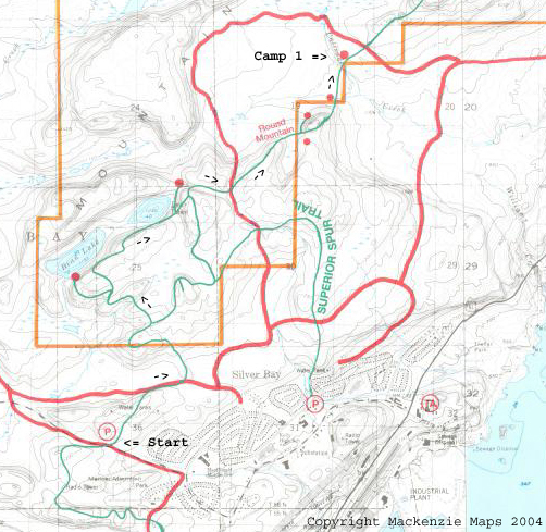
- Day 1 (Friday) - We will leave Burlington Bay by 0900 for the 45 minute drive to the trailhead at Penn Blvd. in Silver Bay. Once on the trail (green lines), we will generally be heading
in a Northeast direction for the remainder of the hike. Total backpacking distance for Day 1 will be 5.5 miles. We will spend our first night on the trail at Palisade Creek campsite.
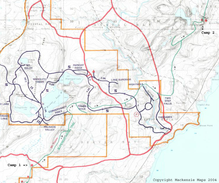
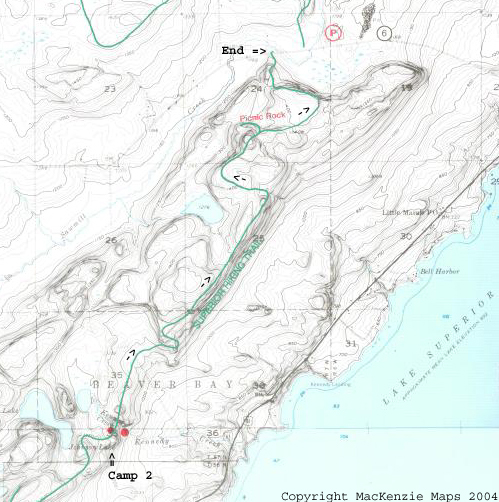
Please note in the following maps:
- Green lines are the Superior Hiking Trail
- Red lines are snowmobile trails
- Blue lines are cross country ski trails
- Orange lines are State Park boundaries
- Day 2 (Saturday) - Starting from Palisade Creek our trail will pass through Tetegouche State Park, lunch at the Baptism River, cross Highway 1 and continue on to West Kennedy Creek campsite.
Total miles for Day 2 will be 7.9 miles.
- Day 3 (Sunday) - Starting from Kennedy Creek our trail will bring us along the tops of some maple tree ridges that are 800' above Lake Superior, expect some nice views!! Afterwards we will go over Sawmill
Dome and Picnic Rock. The end of the trail for us will be at Lake County 6. Total miles for Day 3 will be 4.5 miles.
- JTT graduation will be held at Palisade Head.
From Hwy. 61 and "Outer Drive" (Silver Bay) continue northeast for 2.7 miles. On the right side just beyond the Palisade Baptist Church will be the entrance to Palisade Head. We hope to be at Palisade Head by 2:00 Sunday afternoon.
The vista from Palisade Head is breathtaking and would be well worth the drive alone to come up and see your son's graduation from JTT!!!!
Links
Here are a number of internet links. If you know of any others that should be here, contact Jeff Nast (see below).
If you have any personal questions, comments, suggestions, having trouble with the list server or this web site please
contact Jeff Nast directly at:

To contact Diane Nast via email:

Thank you and God Bless!
Jeff Nast - a.k.a. White Raven (FCF Name) - Genesis 8:7, 1 Kings 17:2, Luke 12:24
Nast family web site
The list server is hosted by Lakeview Christian Academy


![]()


![]()
![]()